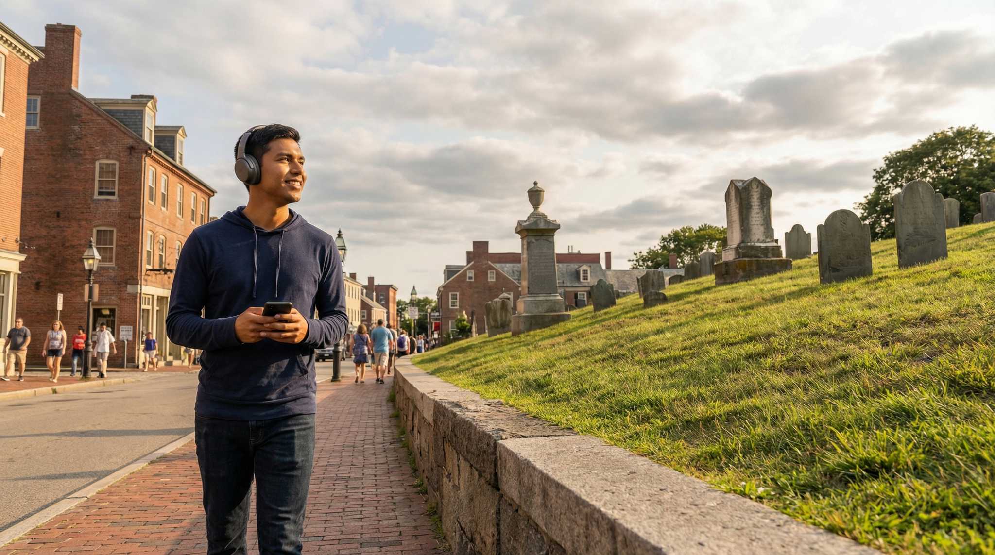
Plymouth Audio Tour: Pilgrim Paths and Colonial Echoes
Beneath Plymouth’s postcard-perfect harbors lurk scars of rebellion, secret meetings, and stories whispered in the shadows of crumbling gravestones. With this self-guided audio tour, wander from the weathered step of Plymouth Rock to the solemn heights of Cole’s Hill and the echoing halls of First Parish Church—unlocking tales most overlook. What blood-chilling truth shattered the calm on a moonless night above Plymouth Harbor? Why did a sacred burial mound almost spark a riot among neighbors? And what scandalous confession once rang out beneath the church’s lofty rafters? Trace the footsteps of pilgrims and plotters, rebels and dreamers. Move through centuries of hope, betrayal, and haunted resolve. The city’s oldest streets pulse with drama for those who know where to listen. History clings to every stone. Start your journey and hear Plymouth’s secrets wake beneath your feet.
Tour preview
About this tour
- scheduleDuration 80–100 minsGo at your own pace
- straighten3.0 km walking routeFollow the guided path
- location_onLocationPlymouth, United States
- wifi_offWorks offlineDownload once, use anywhere
- all_inclusiveLifetime accessReplay anytime, forever
- location_onStarts at Pilgrim Hall Museum
Stops on this tour
lock_open 3 free previews · 9 unlock with purchase
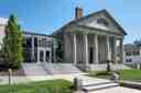
You are looking at a stately building of pale Quincy granite, anchored by a triangular roofline resting on six massive stone columns. This is Pilgrim Hall Museum, the oldest…Read moreShow less
Open dedicated page →
Pilgrim Hall MuseumPhoto: Giorgio Galeotti, Wikimedia Commons, CC BY 4.0. Cropped & resized. You are looking at a stately building of pale Quincy granite, anchored by a triangular roofline resting on six massive stone columns. This is Pilgrim Hall Museum, the oldest continuously operating public museum in the United States, welcoming visitors since eighteen twenty-four.
Imagine standing exactly where you are right now in the eighteen fifties. For fifty years, a massive fragment of the famous Plymouth Rock sat right in front of this building... a strange journey we will uncover later on. Today, a small touchable piece of it is still kept inside for visitors. The museum holds a deep well of history. Glance at your screen for a moment. This is the sixteen fifty-one portrait of Edward Winslow... the only known portrait of a Pilgrim painted while they were actually alive.
If you are here between Wednesday and Sunday from nine thirty A M to five P M, you can step inside to explore these original artifacts. This monument protects the fragile memories of a world forever changed. Take your time, and whenever you are ready, we can walk on to our next stop.
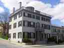
Look to your left for a three-story painted brick building with a perfectly symmetrical shape, featuring a central entryway portico supported by delicate columns.... This is the…Read moreShow less
Open dedicated page →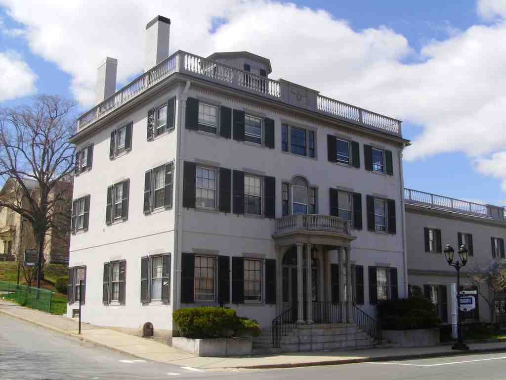
Bartlett–Russell–Hedge HousePhoto: Historical Perspective, Wikimedia Commons, Public domain. Cropped & resized. Look to your left for a three-story painted brick building with a perfectly symmetrical shape, featuring a central entryway portico supported by delicate columns.... This is the Bartlett-Russell-Hedge House, built around eighteen oh three for a prosperous ship's captain named Joseph Bartlett.
This is a prime example of Federal architecture, an early American building style known for its graceful balance and classical details. Notice the elegant Palladian window directly above the main entrance, which is a signature feature of the style... a tall central window with a rounded arch, flanked by two narrower rectangular windows. And right at the very top sits a small structure called a cupola, a perfect lookout point for a captain watching for ships to return. You can see its perfectly balanced proportions clearly on your screen.
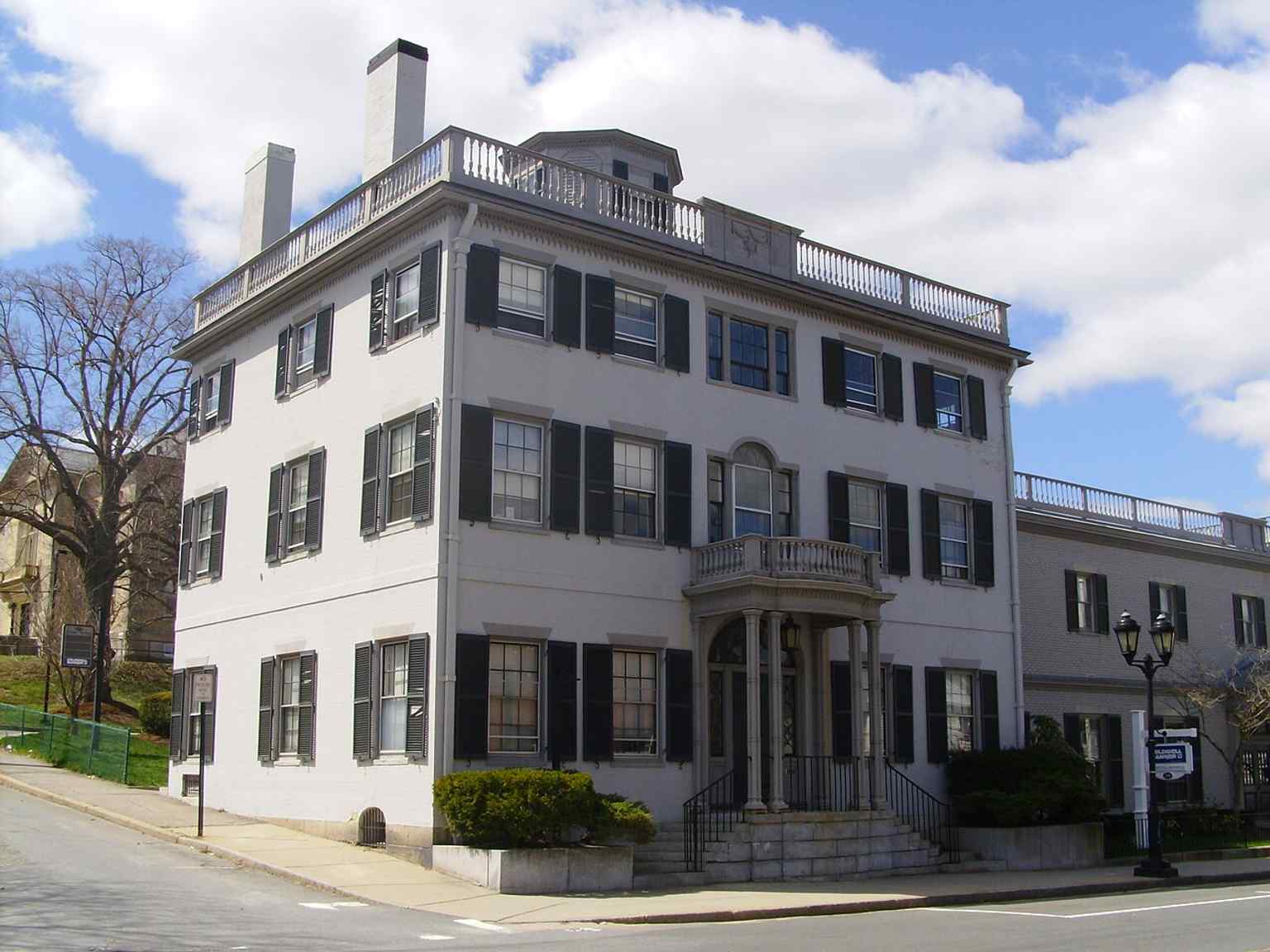
This image captures the Bartlett-Russell-Hedge House, a fine local example of Federal architecture built in 1803 for ship's captain Joseph Bartlett.Photo: Historical Perspective, Wikimedia Commons, Public domain. Cropped & resized. But Captain Bartlett's success did not last. The War of eighteen twelve struck, devastating the maritime trade and ruining Bartlett financially. To save the family estate, his son William took over the property and converted this grand private home into a public inn.
It was in this lively inn that William's son, John, spent his early childhood. Perhaps that exposure to the countless stories of passing travelers inspired him, because John Bartlett would eventually achieve fame as the creator of Bartlett's Familiar Quotations, a massive reference book of famous phrases still used today. The house later passed to local iron merchants, the Russell and Hedge families, before becoming a bank in nineteen fifty-one.
Despite the modern additions hidden in the rear, the proud face of this house still holds the memory of a rising maritime nation. Take your time enjoying the architecture, and whenever you are ready, we will continue our walk.
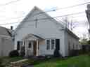
Just ahead is a modest, white clapboard building with a gabled roof and a small portico held up by simple, rounded pillars known as Doric columns. This is the Bethel A-M-E Church.…Read moreShow less
Open dedicated page →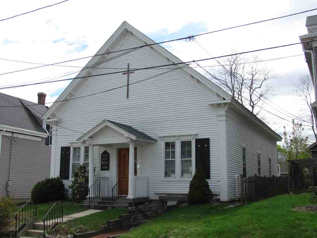
Bethel African Methodist Episcopal Church and ParsonagePhoto: John Phelan, Wikimedia Commons, CC BY-SA 3.0. Cropped & resized. Just ahead is a modest, white clapboard building with a gabled roof and a small portico held up by simple, rounded pillars known as Doric columns. This is the Bethel A-M-E Church. A-M-E stands for African Methodist Episcopal, a Protestant denomination founded by Black Americans seeking religious autonomy and self-determination.
In eighteen fifty, Plymouth had a small African American community of just one hundred and thirty-eight people. Sixteen years later, in eighteen sixty-six, members of this tight-knit group organized their own congregation. They started out gathering in a tiny, converted house, but they soon outgrew it.
If you pull up the photo on your app, you can see the historic exterior of the property they eventually purchased. Surprisingly, this structure was built around eighteen forty for commerce, not worship. Before the congregation bought and consecrated it in eighteen seventy, these walls housed a gymnasium, a shoe shop, and a school.
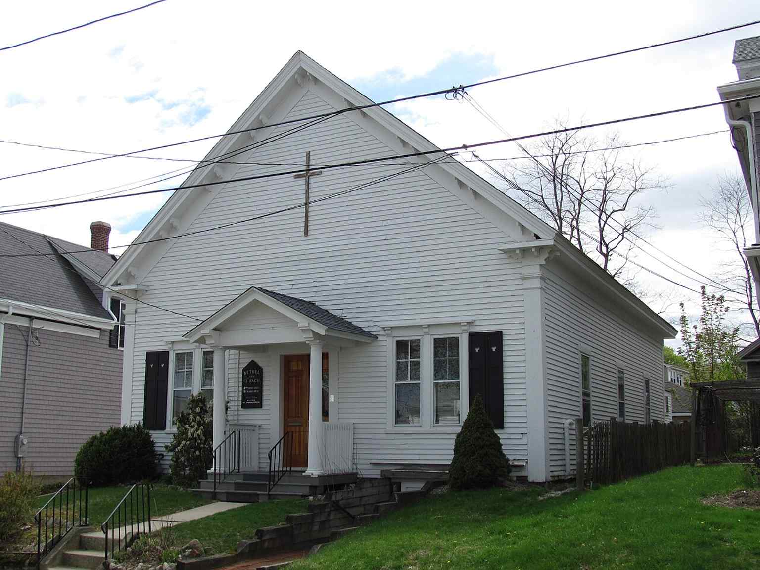
View the Bethel African Methodist Episcopal Church, originally a commercial building from the 1840s, featuring its distinctive Greek Revival-Italianate style with a gabled portico and Doric columns. This building was consecrated as a church in 1870.Photo: John Phelan, Wikimedia Commons, CC BY-SA 3.0. Cropped & resized. The building displays a blend of Greek Revival and Italianate architecture, which means it pairs the structural symmetry of ancient Greek design with decorative, paired brackets tucked up under the roofline.
Just twenty feet behind the sanctuary sits the parsonage, an everyday residential house added in eighteen ninety-five. The pastors who lived there often worked for little to no pay, taking on heavy labor in town just to survive while leading their flock.
This modest wooden church remains a profound anchor of resilience. The building is generally open from nine in the morning to four in the afternoon on weekdays, and for a few hours on Sunday mornings.
Take a moment to reflect here. Whenever you are ready, we can continue to the next stop.
Show 9 more stopsShow fewer stopsexpand_moreexpand_less
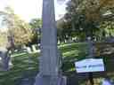
On your right, you will see a tall, pale granite obelisk standing prominently on a grassy slope among older, rounded slate headstones. This is Burial Hill. Before this hill…Read moreShow less
Open dedicated page →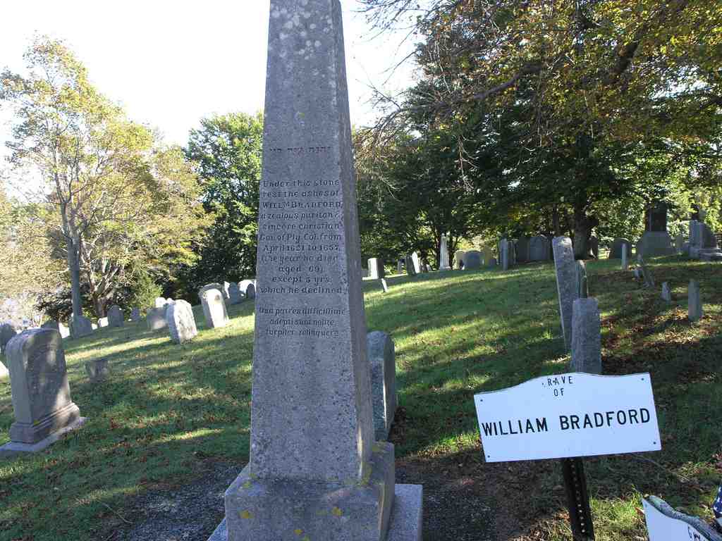
Burial HillPhoto: Bfrance2002, Wikimedia Commons, Public domain. Cropped & resized. On your right, you will see a tall, pale granite obelisk standing prominently on a grassy slope among older, rounded slate headstones. This is Burial Hill.
Before this hill became a final resting place, it was a place of survival. Rising one hundred sixty-five feet above sea level, it offered the early settlers a sweeping, commanding view over Plymouth Bay and the surrounding landscape. In sixteen twenty-one, they built a fort right up here at the summit. Take a look at your screen to see a reconstruction of that sturdy wooden fort and meeting house, which you can visit today at the nearby Plymouth Plantation.
That original fort was the heart of the community. It functioned not just as a defense, but as a gathering space for the colony and the original meeting house for the First Parish Church, serving that dual purpose until sixteen seventy-seven. But as the colony grew and the need for a fortified hilltop faded, the land transitioned into a burying ground.
Today, there are over two thousand marked graves scattered across these five point one acres, with stones dating from sixteen eighty all the way to nineteen fifty-seven. You are standing among the founders of the Plymouth Colony. Glance at your app for a moment to see the grave of William Bradford. He was a Mayflower passenger and the long-serving governor who documented much of the colony's fragile early history. You will also find Mary Allerton resting here, the very last surviving Mayflower passenger.
There are also several cenotaphs upon this hill. A cenotaph is simply an empty tomb or monument erected in honor of a person whose remains are buried elsewhere. For example, Robert Cushman, the chief organizer of the Mayflower expedition, is memorialized here with a stone, even though his actual resting place is unknown.
This hill holds centuries of quiet memory, keeping watch over the town it helped create. Take a moment to soak this in, and when you are ready, we can walk together to the next stop.
Notice the weathered dark wooden structure with a steeply pitched roof and small, diamond-paned windows. You can pull up the exterior photo on your screen to see its simple,…Read moreShow less
Open dedicated page →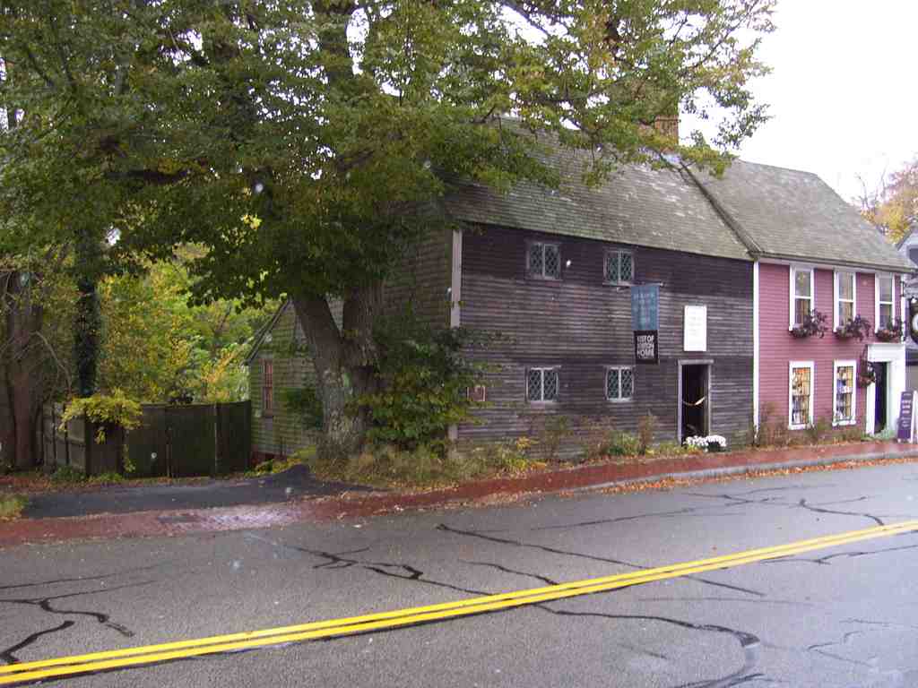
Richard Sparrow HousePhoto: Swampyank, Wikimedia Commons, CC BY-SA 3.0. Cropped & resized. Notice the weathered dark wooden structure with a steeply pitched roof and small, diamond-paned windows. You can pull up the exterior photo on your screen to see its simple, enduring profile. This is the Richard Sparrow House, the absolute oldest surviving home in Plymouth. Richard Sparrow was an English surveyor who arrived in sixteen thirty-six. Almost immediately, he was granted a sixteen-acre tract of land, where he used his careful eye for measurement to construct this house around sixteen forty. Imagine the precise, deliberate work required to build a permanent anchor in a rugged new settlement. Though Sparrow moved to Eastham in sixteen fifty-three, this sturdy dwelling stayed put. In nineteen seventy-four, it was added to the National Register of Historic Places, marking its significance in the Plymouth Village Historic District. Today, you can explore it as a house museum and art gallery, which is open Tuesdays, Thursdays, Fridays, and Saturdays from ten A-M to five P-M. It is a quiet testament to early colonial endurance. Take all the time you need here, and when you are ready, we will continue on our route.
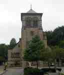
Look to your right for a sturdy stone building featuring a prominent square tower topped with a pyramidal roof and arched windows. This is the First Parish Church. Its…Read moreShow less
Open dedicated page →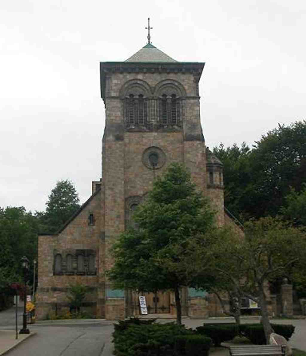
First Parish Church in PlymouthPhoto: Raime, Wikimedia Commons, CC BY-SA 3.0. Cropped & resized. Look to your right for a sturdy stone building featuring a prominent square tower topped with a pyramidal roof and arched windows. This is the First Parish Church. Its congregation traces all the way back to sixteen oh seven. When the Pilgrims arrived in sixteen twenty, they held services aboard the Mayflower, and later at the fort up on Burial Hill, which we explored earlier. They constructed their first real church on this square in sixteen forty-eight. Check your screen to see the eighteen thirty-one wooden Gothic structure that stood here before this one. Over the centuries, the community evolved. In eighteen oh one, a schism split the congregation when many adopted Unitarianism, prompting dissenting traditionalists to break away. This Romanesque building was finished in eighteen ninety-nine. If you look at your app, you can view the breathtaking sanctuary. It features brilliant Tiffany stained glass and soaring hammer beam construction, a dramatic architectural method using carved quarter-sawn oak to support the heavy roof. Note that the building is only open to visitors Tuesday through Thursday mornings. Take a moment to soak this in. When you are ready, we can head to the next stop.
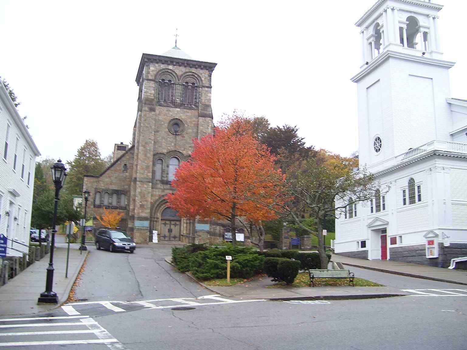
The First Parish Church, built in 1899 in the Romanesque style, was listed on the National Register of Historic Places in 2014.Photo: Swampyank at en.wikipedia, Wikimedia Commons, CC BY-SA 3.0. Cropped & resized. Look for the sloping road framed by wooden clapboard houses and a low stone retaining wall. Welcome to Leyden Street. Before Christmas in sixteen twenty, the Pilgrims disembarked…Read moreShow less
Open dedicated page →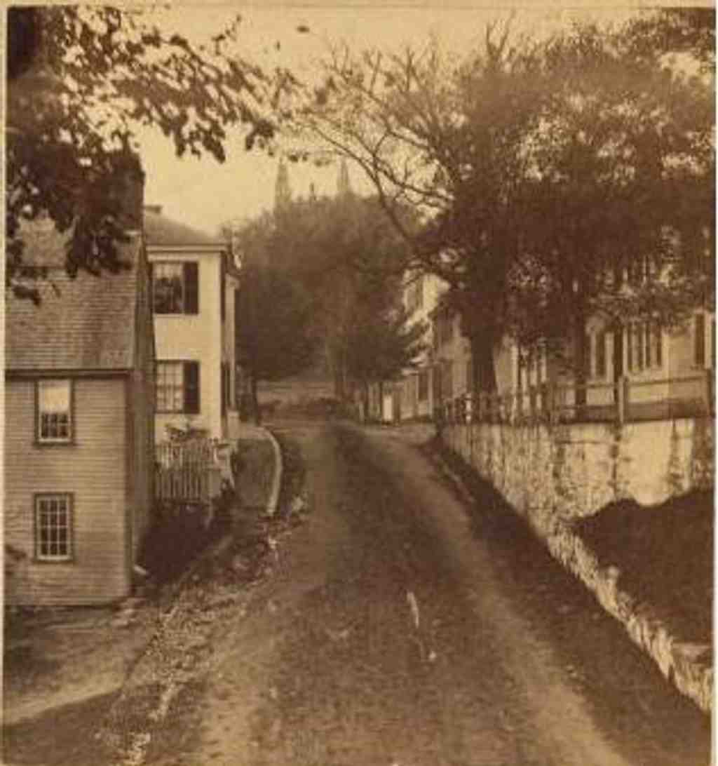
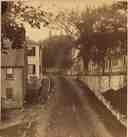
Leyden StreetPhoto: Rogers, C. H. -- Photographer, Wikimedia Commons, Public domain. Cropped & resized. Look for the sloping road framed by wooden clapboard houses and a low stone retaining wall. Welcome to Leyden Street. Before Christmas in sixteen twenty, the Pilgrims disembarked the Mayflower and began laying out this exact path. They built their modest houses from the shore up to the base of Burial Hill, which you can see illustrated on your screen.
This was a practical choice, as the adjacent Town Brook provided fresh drinking water. Governor William Bradford and Doctor Samuel Fuller owned lots right along this road, and the famed First Thanksgiving was likely held nearby in sixteen twenty-one. You can check your app for a glimpse of how the rough-hewn street appeared by sixteen twenty-seven. Originally called First Street, it was renamed in eighteen twenty-three to honor the city in Holland that offered the Pilgrims refuge. Because people have lived here uninterrupted since those first arrivals, this is the oldest continuously inhabited street in the thirteen colonies.
It is humbling to stand where history took such monumental steps. Whenever you are ready, we can make our way to the next stop.
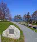
You are looking at a steeply rising grassy landscape anchored by a large, rugged granite boulder bearing a dark rectangular plaque, marking the entrance to a winding path. This is…Read moreShow less
Open dedicated page →
Cole's HillPhoto: Daniel Case, Wikimedia Commons, CC BY-SA 3.0. Cropped & resized. You are looking at a steeply rising grassy landscape anchored by a large, rugged granite boulder bearing a dark rectangular plaque, marking the entrance to a winding path. This is Cole's Hill. Underneath this manicured lawn lies the heavy history of the Pilgrims' first, devastating winter in New England.
In the winter of sixteen twenty to sixteen twenty-one, fifty-two of the original one hundred and two Mayflower settlers died. Up to fifty of them were buried quietly right here, on this slope facing the sea. Over time, however, the hill completely lost its identity as a graveyard. The land was deeded to Samuel Fuller, the colony's physician, and later to a man named James Cole, who ran a tavern here in the sixteen forties. Because of its commanding view of the harbor, the town repeatedly used the hill to build defensive forts, throwing up earthworks in seventeen forty-two, again during the Revolutionary War, and once more in eighteen fourteen.
But the forgotten dead refused to stay buried.
In seventeen thirty-five, a severe storm sent a torrent of water pouring down nearby Middle Street, carving a ravine into the hill and washing many human remains straight into the harbor. Later, in eighteen fifty-five, workers laying a public conduit - a large pipe for the town's water supply - unearthed a grave containing two skeletons. One had a particularly prominent forehead, leading people to romantically assume they had found John Carver, the first governor, and his wife. In eighteen seventy-nine, spectators watching another excavation actually pocketed some of the exposed bones to keep as souvenirs.
These accidental discoveries eventually confirmed the old oral traditions about the hill. The skeletons were laid out on an east-to-west axis, with their heads pointing west. This was a traditional Christian burial practice, meant to allow the dead to face the rising sun on Judgment Day. Furthermore, no personal items were buried with the bodies, pointing clearly to European rather than Wampanoag burials.
By the early twentieth century, the town sought to properly honor this space. If you check your screen, you can see a photo of how the hill looked before this effort, back in eighteen sixty-five, compared to its polished state today. Around nineteen twenty, to mark the three hundredth anniversary of the Pilgrim landing, buildings were cleared away to transform the area into the public park you see now.
During this time, a massive granite sarcophagus - a large above-ground stone tomb - was erected at the southern end of the hill to finally give those disturbed remains a permanent, respectful resting place. The town also added a bronze statue of Massasoit, the paramount leader, or sachem, of the Wampanoag people, honoring the critical support his people provided which allowed the surviving settlers to live through those early years. You can view a photo of this striking monument on your app.
For your planning, the park is generally open weekdays from seven thirty A-M to four P-M, with extended hours on Tuesdays, a noon closure on Fridays, and closed entirely on weekends.
Take a moment to look out over the bay where that famous ship once dropped anchor. When you are ready, we can walk together to our next destination.

Cole's Hill, now a public park, was the site of the first cemetery used by Mayflower Pilgrims in 1620 and is a National Historic Landmark.Photo: Daniel Case, Wikimedia Commons, CC BY-SA 3.0. Cropped & resized. As you walk, take in the gently curving paved street framed by stout red brick buildings with crisp white windows. This is the Plymouth Village Historic District, tracing the…Read moreShow less
Open dedicated page →
Plymouth Village Historic DistrictPhoto: Historical Perspective, Wikimedia Commons, Public domain. Cropped & resized. As you walk, take in the gently curving paved street framed by stout red brick buildings with crisp white windows. This is the Plymouth Village Historic District, tracing the footprint of the earliest Plymouth Colony settlement. Picture the rough dirt paths that once ran precisely where this pavement lies. By sixteen thirty-three, streets like Leyden Street, which we crossed earlier, were officially laid out right here. This district, bounded by North Street and Town Brook, holds the oldest surviving timber homes in the area, like the sixteen forty Richard Sparrow House. Take a glance at your phone for a broader view of the district today. The Pilgrims landed in sixteen twenty just steps away, entering an unfamiliar world to build a society from the ground up. Check your screen to see a replica of the ship they arrived on, safely anchored nearby. Added to the National Register of Historic Places in nineteen eighty-two, this quiet network of roads holds the original map of their survival. The very beginnings of a nation were mapped along these boundaries. When you are ready, let us walk to the next stop.
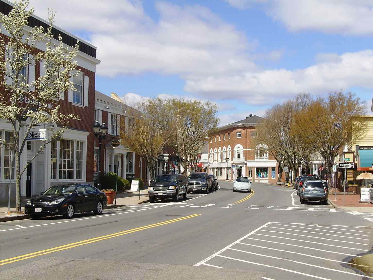
A broad view of the Plymouth Historic District, officially listed on the National Register of Historic Places in 1982.Photo: Historical Perspective, Wikimedia Commons, Public domain. Cropped & resized. 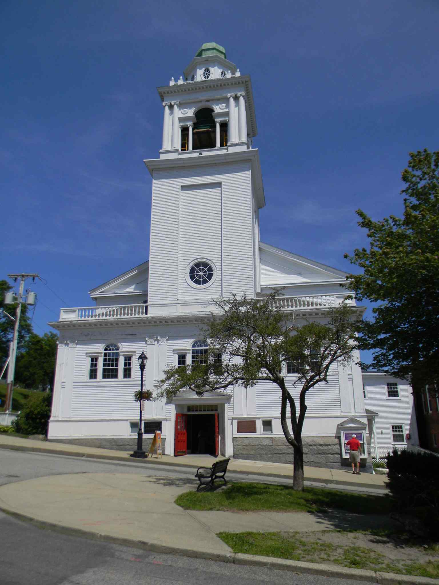
The stately Church of the Pilgrimage, a significant landmark within the Plymouth Village Historic District, the area of earliest settlement of the Plymouth Colony.Photo: Upstateherd, Wikimedia Commons, CC BY-SA 4.0. Cropped & resized. 
The Joseph Tribble House, dating to around 1794, represents the historic architecture found throughout the Plymouth Village Historic District, home to some of Plymouth's oldest surviving houses.Photo: Upstateherd, Wikimedia Commons, CC BY-SA 4.0. Cropped & resized. 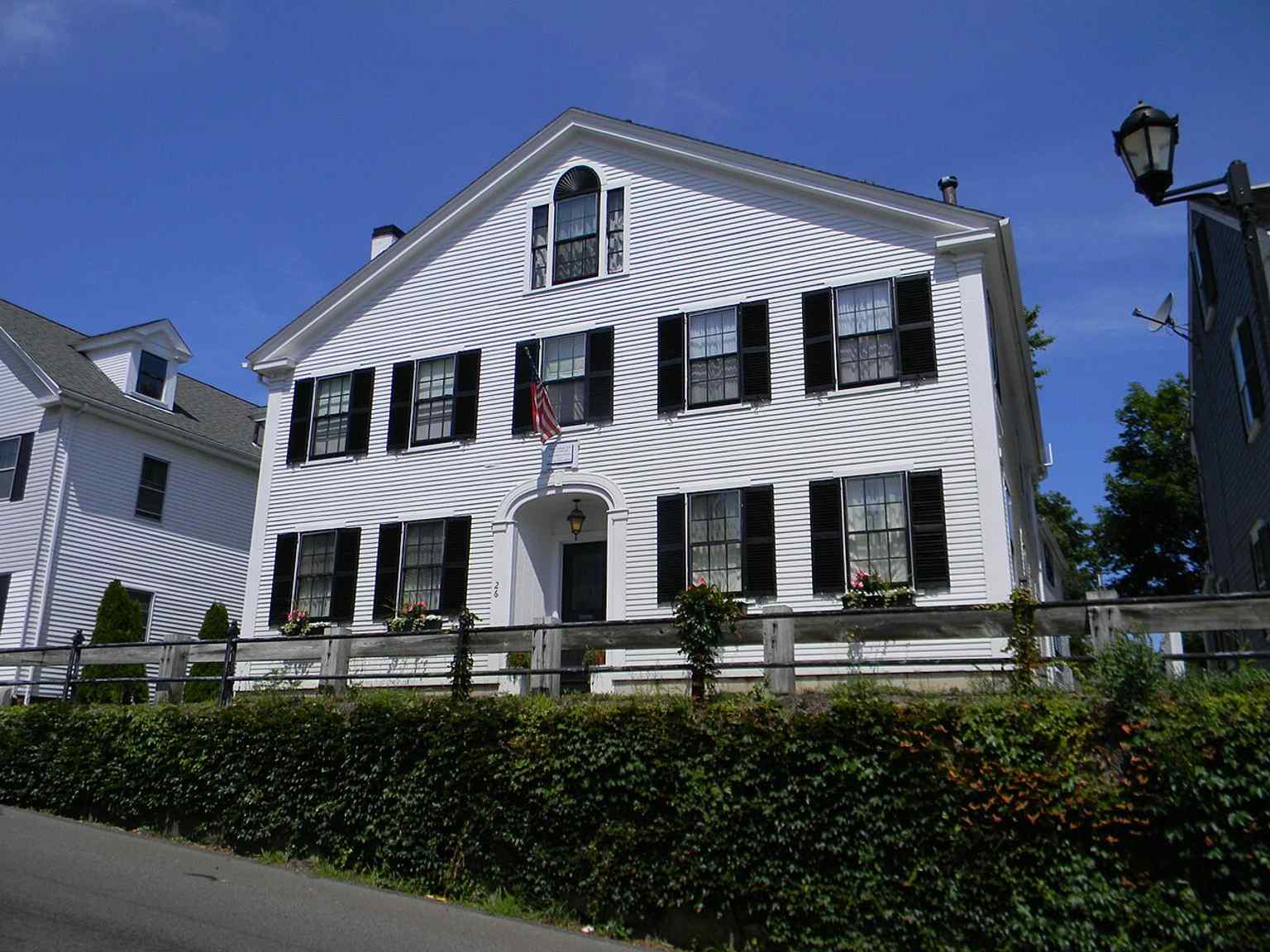
The Parsonage Lot, part of the Plymouth Village Historic District, which features streets laid out as early as 1633.Photo: Upstateherd, Wikimedia Commons, CC BY-SA 4.0. Cropped & resized. 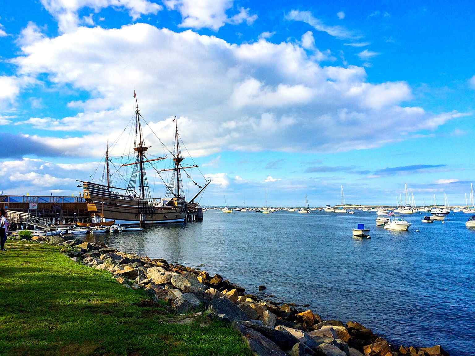
The Mayflower II replica, docked near the Plymouth Village Historic District, symbolizing the Pilgrims' landing in 1620 near Plymouth Rock.Photo: John8v12, Wikimedia Commons, CC BY-SA 4.0. Cropped & resized. On your left is Plymouth Rock. You will see a large, roughly oval grey boulder resting in the sand, defined by a heavy diagonal seam where it was repaired and the date sixteen…Read moreShow less
Open dedicated page →On your left is Plymouth Rock. You will see a large, roughly oval grey boulder resting in the sand, defined by a heavy diagonal seam where it was repaired and the date sixteen twenty deeply engraved into its surface.
For a stone of such monumental fame, it might seem surprisingly small. The Mayflower Pilgrims actually never wrote about this rock. In the foundational writings of Edward Winslow and William Bradford, there is no record of stepping onto this specific granite boulder. In fact, they had already landed and explored Provincetown a month earlier.
The story we know did not begin until one hundred twenty-one years later. In seventeen forty-one, the town planned to build a wharf over this exact spot. Hearing this, a ninety-four-year-old church elder named Thomas Faunce caused quite a stir. His father had arrived in sixteen twenty-three, and Faunce claimed his father told him this was the original landing place. He was carried to the shore in a chair, where he reportedly wept and bid an emotional farewell to the rock. The town was so moved, they built the wharf around the stone, leaving the top visible.
But the rock did not stay put. In seventeen seventy-four, the townspeople decided to move it. The massive stone, originally estimated to weigh twenty thousand pounds, was rigged up to be hauled away. The attempt failed dramatically. The immense weight caused the boulder to crack entirely in two. Take a look at your screen for a high-resolution view clearly showing the fault line where the stone fractured.
The bottom half stayed at the wharf, while the top half was dragged to the town meeting house, and later to the Pilgrim Hall Museum. Over the decades, souvenir hunters chipped away hundreds of pounds of the remaining shoreline rock. What you see today is only about a third of the original boulder. The pieces were finally reunited and cemented together in eighteen eighty, which is when the date sixteen twenty was permanently carved into the stone.
Finally, in nineteen twenty, the waterfront was landscaped by Arthur Asahel Shurcliff. A grand Roman Doric portico, which is the classical open-sided stone monument with columns towering above you, was built by the architectural firm McKim, Mead, and White to protect the rock at water level.
The French writer Alexis de Tocqueville noted this strange phenomenon in eighteen thirty-five, marveling at how a simple stone pressed for an instant by outcasts became treasured as a relic by a great nation. If you pull up the app, you will notice that while Plymouth Rock itself has remained largely unchanged over the last four decades, the shifting sands and modern photography capture the timeless endurance of this iconic symbol of American history.
This state park memorial is open twenty-four hours a day, every day of the week, so the rock is always accessible to those who seek it. Take a moment to soak this in. When you are ready, we can head to the next stop.
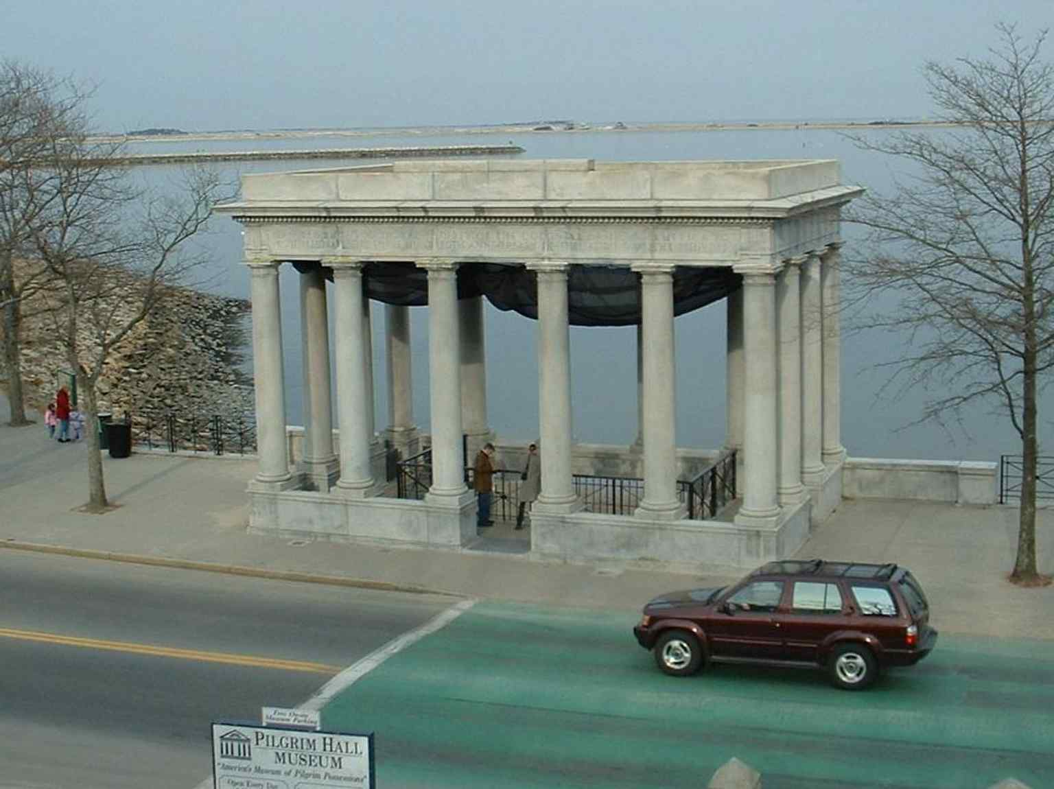
This granite portico, designed by McKim, Mead & White, was erected in 1920 to protect Plymouth Rock at its current location.Photo: Plymouth_Rock_Monument.jpg: T.S. Custadio aka ToddC4176 at en.wikipedia derivative work: Jeeny at en.wikipedia, Wikimedia Commons, CC BY-SA 3.0. Cropped & resized. 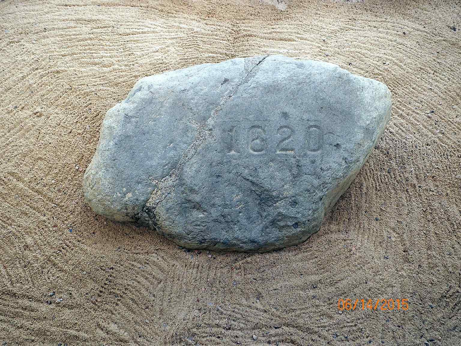
The iconic date "1620" was carved into Plymouth Rock when it was rejoined and returned to the shoreline in 1880, after being split in 1774.Photo: Rhonda McCloughan (Pr41799), Wikimedia Commons, CC BY-SA 4.0. Cropped & resized. 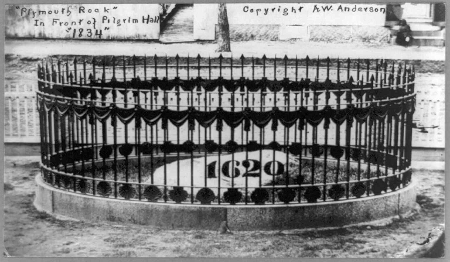
After breaking in 1774, one portion of Plymouth Rock was moved to Pilgrim Hall Museum in 1834, where it remained for decades.Photo: Miscellaneous Items in High Demand, PPOC, Library of Congress, Wikimedia Commons, Public domain. Cropped & resized. 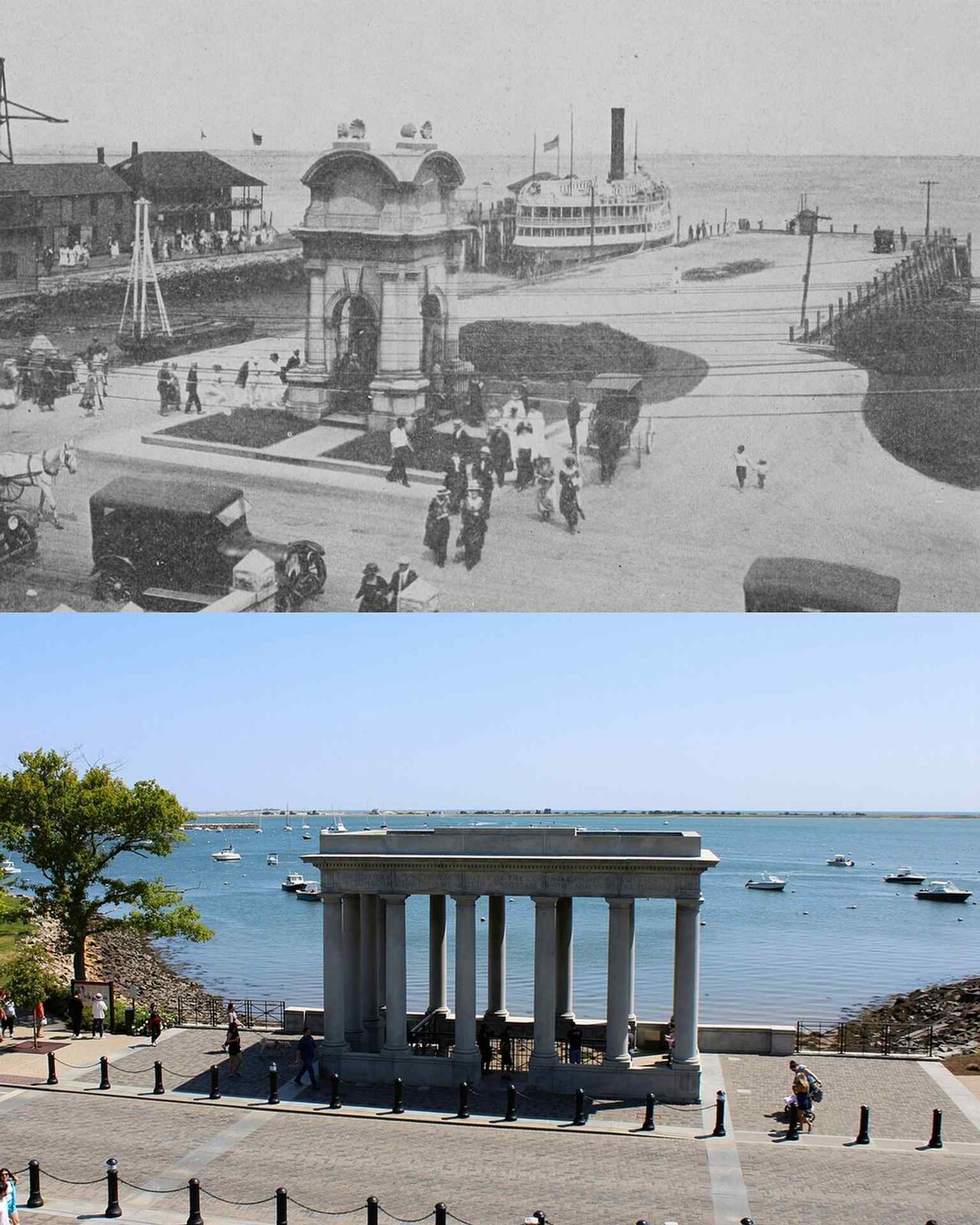
This image showcases the ornate Victorian canopy designed by Hammatt Billings, which protected Plymouth Rock from 1867 until it was replaced in 1920.Photo: Raymond H. Fogler Library, Wikimedia Commons, CC BY-SA 4.0. Cropped & resized. 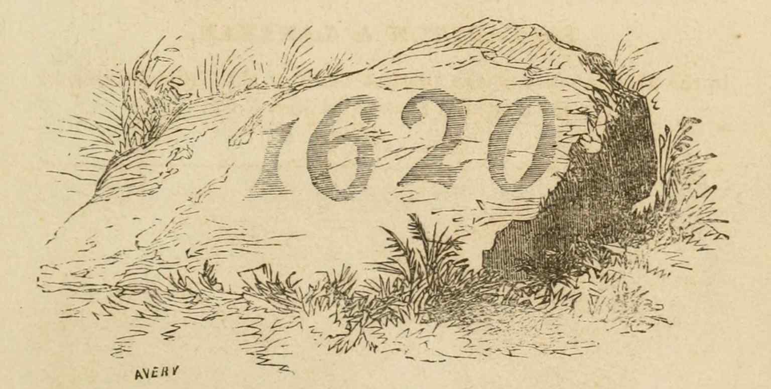
This 1869 depiction shows Plymouth Rock under the Victorian canopy that was completed in 1867, illustrating an earlier phase of the rock's history.Photo: Z. A. Mudge, Wikimedia Commons, Public domain. Cropped & resized. 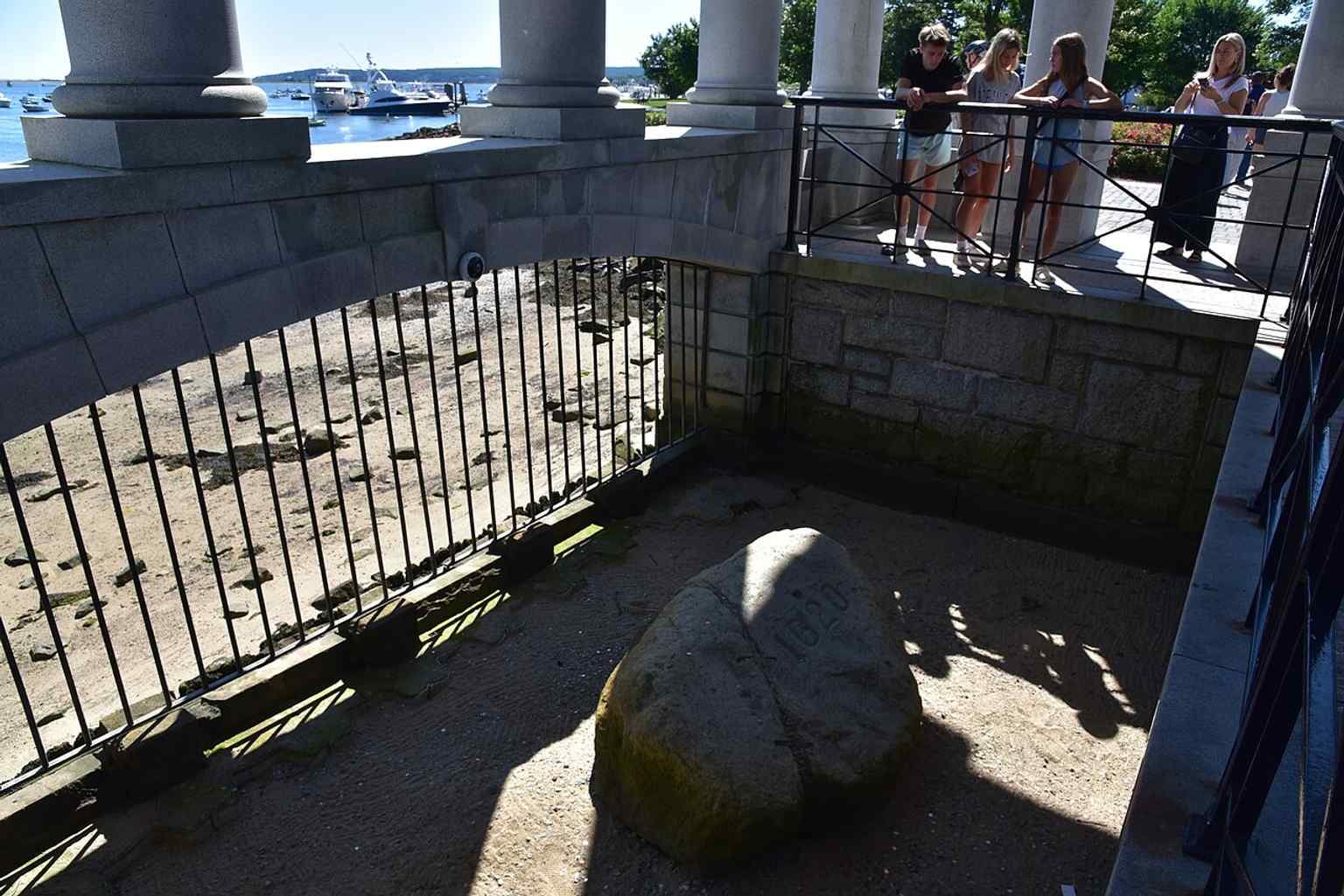
Today, visitors peer down at Plymouth Rock, which is now managed by the Department of Conservation and Recreation as part of Pilgrim Memorial State Park.Photo: Dclo, Wikimedia Commons, CC BY-SA 4.0. Cropped & resized. 
This 1876 artwork depicts an imagined landing of the Pilgrims, illustrating the popular legend associated with Plymouth Rock despite no early accounts mentioning it.Photo: Unknown artist (and unknown engraver) via William Cullen Bryant and Sydney G. Howard (Internet Archive Book Images), Wikimedia Commons, CC0. Cropped & resized. 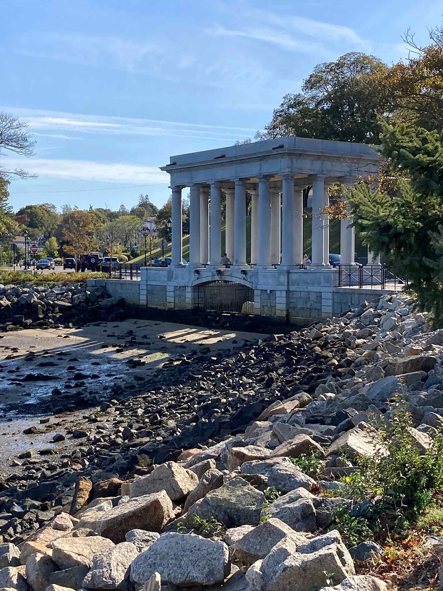
In 1920, Plymouth Rock was strategically relocated to be at water level, making it appear tide-washed at low tide.Photo: 4myboyz2, Wikimedia Commons, CC BY-SA 4.0. Cropped & resized. On your left, you will notice a large building clad in white wooden siding, distinguished by its steeply pitched roof and twin red brick chimneys. This is the Bradford-Union…Read moreShow less
Open dedicated page →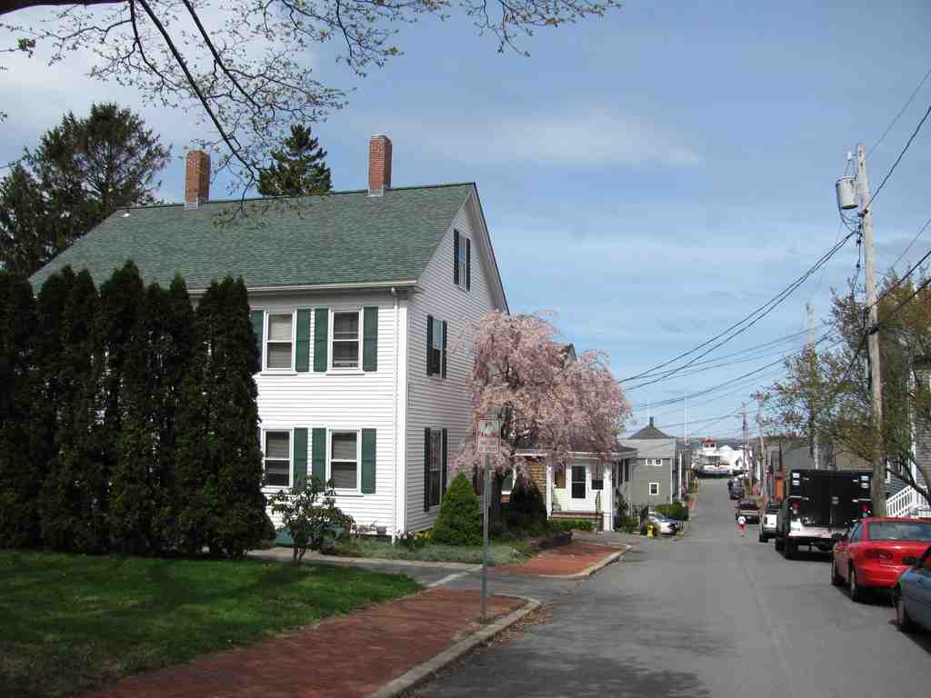
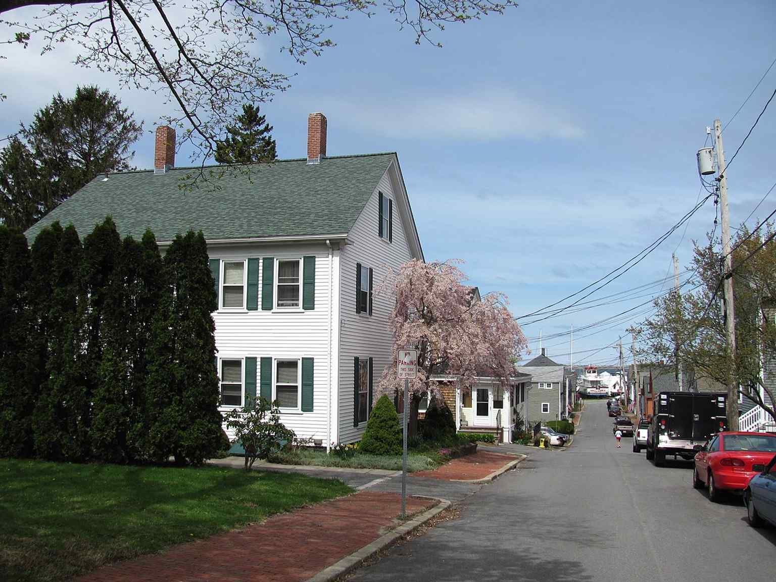
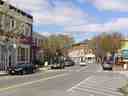
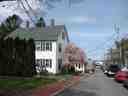
Bradford–Union Street Historic DistrictPhoto: John Phelan, Wikimedia Commons, CC BY-SA 3.0. Cropped & resized. On your left, you will notice a large building clad in white wooden siding, distinguished by its steeply pitched roof and twin red brick chimneys. This is the Bradford-Union Street Historic District, a seven-acre neighborhood revealing a different chapter of Plymouth. We often focus on this town's earliest days, but by the eighteen and nineteen hundreds, it had transformed into a booming maritime center.
In eighteen twelve, Samuel Doten built the first wharf southeast of the mouth of Town Brook. As maritime industries expanded, the people working those ships needed places to live. That is where Alden Harlow saw an opportunity. In the eighteen forties, Harlow developed Bradford Street as a speculative real estate venture. He built a series of vernacular, one-and-a-half-story cottages. Vernacular simply means they were built in a practical, local style rather than a grand architectural tradition, and they featured three-bay fronts, meaning the exterior was evenly divided into three sections for doors and windows.
You can check your screen to see an example of these modest cottages along the street.
Explore Bradford Street, a key part of this historic district known for the vernacular 1-1/2 story cottages developed by Alden Harlow in the 1840s.Photo: John Phelan, Wikimedia Commons, CC BY-SA 3.0. Cropped & resized. These homes formed a tight community of workers just up the hill from the water. Today, the area is almost entirely residential, with roads funneling down toward the sea just as they did centuries ago. If you plan to look inside the local historical buildings, note they operate Monday through Friday from nine thirty A-M to four P-M, Saturdays until noon, and are closed on Sundays.
The quiet dignity of this working neighborhood remains beautifully preserved in its simple architecture. Take a moment to appreciate the streetscape, and whenever you are ready, we will head to the next stop.
Turn your attention to the two-story, weathered wood-frame house with diamond-paned windows and a massive central brick chimney. Built in sixteen sixty-seven by Jacob Mitchell,…Read moreShow less
Open dedicated page →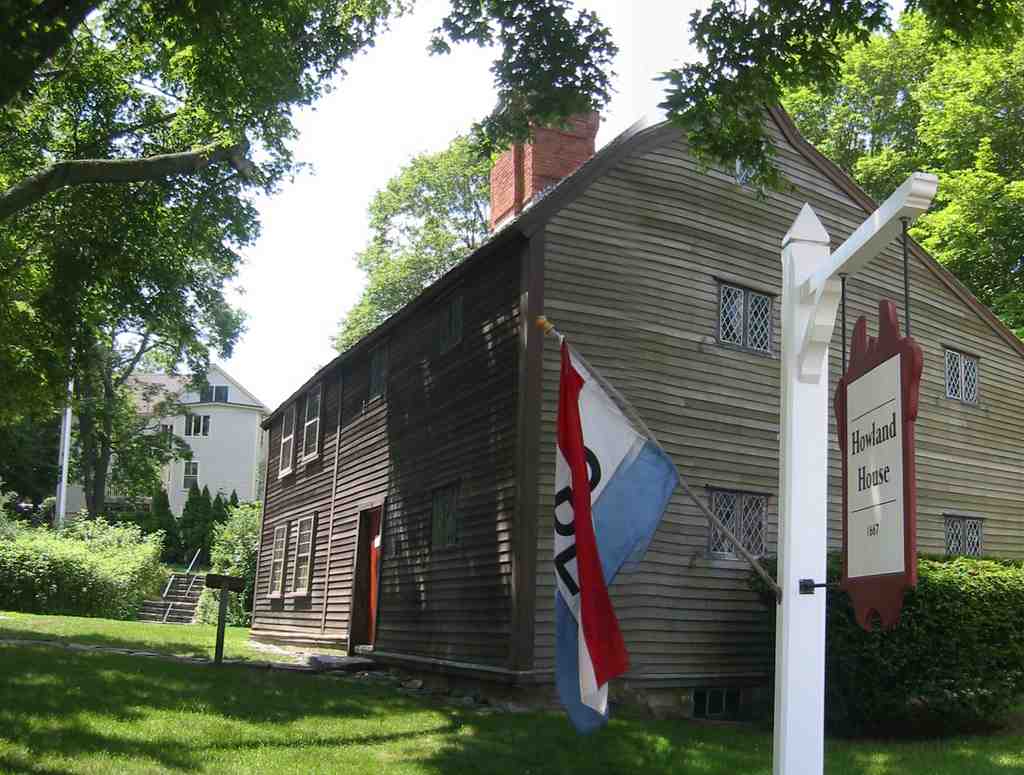
Jabez Howland HousePhoto: Howland7797, Wikimedia Commons, Public domain. Cropped & resized. Turn your attention to the two-story, weathered wood-frame house with diamond-paned windows and a massive central brick chimney. Built in sixteen sixty-seven by Jacob Mitchell, this structure at thirty-three Sandwich Street was soon purchased by Jabez Howland. Jabez was the son of John and Elizabeth Tilley Howland, two original Pilgrims who survived the Mayflower crossing. It is profound to stand before a structure that actually sheltered the immediate family of those first arrivals.
The building remained a private residence for generations, continuously occupied until nineteen fifteen. You can easily see how the streetscape evolved around it if you check out the before and after image on your screen. Take another glance at your app to see a nineteen twenty-one photograph, capturing the house prior to its extensive nineteen forties restoration.
Today, the Pilgrim John Howland Society operates the property as a museum, thoughtfully filling its rooms with authentic seventeenth-century furnishings. Added to the National Register of Historic Places in nineteen seventy-four, it endures as a rare, tangible link to the founding generation of Plymouth, making it the perfect place to conclude our journey.


Frequently asked questions
How do I start the tour?
After purchase, download the AudaTours app and enter your redemption code. The tour will be ready to start immediately - just tap play and follow the GPS-guided route.
Do I need internet during the tour?
No! Download the tour before you start and enjoy it fully offline. Only the chat feature requires internet. We recommend downloading on WiFi to save mobile data.
Is this a guided group tour?
No - this is a self-guided audio tour. You explore independently at your own pace, with audio narration playing through your phone. No tour guide, no group, no schedule.
How long does the tour take?
Most tours take 60–90 minutes to complete, but you control the pace entirely. Pause, skip stops, or take breaks whenever you want.
What if I can't finish the tour today?
No problem! Tours have lifetime access. Pause and resume whenever you like - tomorrow, next week, or next year. Your progress is saved.
What languages are available?
All tours are available in 50+ languages. Select your preferred language when redeeming your code. Note: language cannot be changed after tour generation.
Where do I access the tour after purchase?
Download the free AudaTours app from the App Store or Google Play. Enter your redemption code (sent via email) and the tour will appear in your library, ready to download and start.
If you don't enjoy the tour, we'll refund your purchase. Contact us at [email protected]
Checkout securely with 


.jpg)
.jpg)