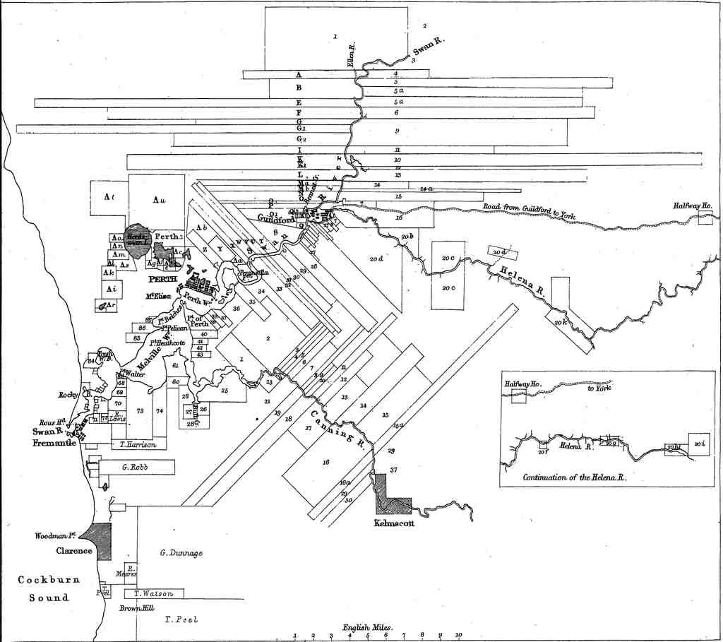
Directly in front of you, you’ll spot a large, black-and-white historical map covered in long, thin rectangles crisscrossing rivers, with the area around Perth at its heart-so just look for the dense cluster of lines and names that seem to tangle up around the rivers between Perth and Fremantle.
Alright, let’s step back in time-don’t worry, you won’t need to dodge any horse-drawn carts! You’re now standing at the site of one of the most quirky and ambitious land schemes in Australian history: the land grants of the Swan River Colony. Picture this: it’s 1829, and fresh-faced British settlers are spilling out onto the untamed banks of the Swan and Canning Rivers. Imagine the air is thick with anticipation, and every corner smells of hope (maybe mixed with a hint of livestock and wet soil).
Now here’s the twist-the British crown didn’t just hand over land willy-nilly. No, in this colony, settlers were “rewarded” with land based on the value of what they dragged over with them: cattle, tools, furniture, you name it. The more “stuff” you brought, the more land you got. For every £3 worth of assets, you could claim 16 hectares (that’s 40 acres-enough room for a mega veggie garden and a cricket pitch or two). But the real comedy show was in the valuations: authorities decided what your stuff was worth, and they weren’t exactly accountants. General cargo was dismissed, but some cattle-and would you believe it, even two rabbits-could net you a whopping 81 hectares (over 200 acres). Maybe they thought giant rabbits would take over the land?
Cash didn’t count at all, so folks would load up their ships with as much fancy, but sometimes completely useless, capital as possible. Imagine trying to impress with a shiny plough that simply sunk in the local soil! It’s little surprise that many soon found themselves penniless and surrounded by expensive, but impractical, gear, which eventually left a lasting mark on the colony’s struggling economy.
But wait, there was a loophole for hiring people! If you paid to bring out adults or children-free passage for your new mates-you could claim even more land. What this really meant was a swarm of indentured servants: people who worked for their keep but didn’t earn a real wage until they “paid off” their voyage. As the colony grew, this system trapped workers and made shopping in the markets a quiet affair. Everyone was too busy working off a debt instead of spending their shillings in town.
Now, you might notice all those ribbon-like strips on the old map in front of you. This design wasn’t artsy-Governor Stirling and Surveyor-General John Septimus Roe quickly learned the best farmland was a skinny stretch along the riverbanks, already bagged by officials and officers. So, the rest of the settlers got these long, awkward “ribbons”-each thin strip clinging to the river for dear life but stretching far out of town into rough bush.
If you received a land grant, you didn’t actually own it yet. You only had the right to occupy the land until you “improved” every single acre by planting, fencing, or building, at least up to a set monetary value. Could you be a clever cheat? Some certainly tried. George Fletcher Moore wrangled half of another settler’s grant simply by promising to make all the needed improvements. Yet most folks found these rigid rules led them to spread their time and money too thinly across vast sections of wilderness.
Not all grants had strings attached. Some big-wigs-like Stirling himself, Charles Fremantle, and Thomas Peel-were gifted massive parcels just for being who they were, or for military service. Large swathes stayed undeveloped, locked up for speculation while everyone else struggled on.
Over the years, the rules changed again and again. Land grants shrank, improvement deadlines became stricter, and eventually, in 1832, free land was out and public auctions were in. Those long, thin farms? Most were only productive at the river’s edge. When new laws allowed settlers to “surrender” worthless sections for title to good bits, the rich simply grabbed better land elsewhere-concentrating wealth and stretching settlement even thinner.
And what about the Noongar people, whose land this truly was? Not even a nod. Fencing went up; sacred sites and hunting grounds were blocked. Just south of Perth, the Noongar Beeliar group couldn’t get to their rivers anymore-a loss far deeper than any line on a map.
So as you study those curious strips and names, you’re glimpsing dreams, ambitions, mistakes, and consequences that shaped the very streets you stroll today. And remember-if you ever find yourself offered 200 acres for a couple of rabbits, check the fine print!
Eager to learn more about the land grants for settlers, improvement conditions or the other land grants? Simply drop your inquiries in the chat section and I'll provide the details you need.